RECENT COMMENTS
Old and Historic District for Church Hill North
Laura Dabb has a turn as a Richmond Times-Dispatch guest columnist today with Zoning Overlay: Church Hill North Area Deserves Old and Historic District Label.
From the column:
In 2007, as we celebrate the 400th birthday of Jamestown and the Richmond region, we are also observing the 50th anniversary of the City of Richmond’s first Old and Historic District. Since creating the St. John’s Old and Historic District in 1957, along with the establishment of the Commission of Architectural Review (CAR) to administer and protect the area, the City Council has gone on to create 13 additional districts and numerous individual historic sites, bringing a total of 2,600 properties under the custodial eye of the CAR.
[…]
Our neighborhood started as an ethnically and economically diverse community, and its current inhabitants still reflect the original population. We have not been as fortunate at retaining our infrastructure. Many buildings, vacant lots, and green spaces are now endangered and need our stewardship. Once they are gone, they are gone forever. With an Old and Historic District in place, we can revitalize our community through responsible growth while protecting the historic charm and beauty that makes Church Hill North such a desirable place to live.
See also:
– Church Hill North Archives
– Church Hill North Historic District Yahoo group


I like to see the older buildings restored to preserve our history and I think that the green belts are equally as important.
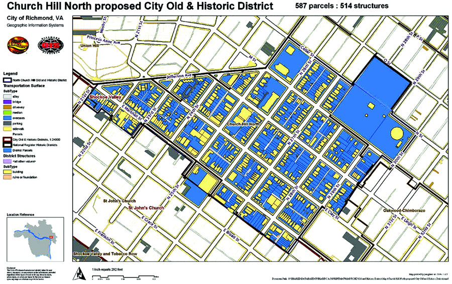
Anyone know why the blocks between Cedar and O, and 25th and 27th weren’t included?
When I first stated organizing this, I put notices in the CHA newsletter and other places around the neighborhood, asking people to join the task force. From that, the boundaries were decided after several planning meetings with various neighbors in the district attending. Originally the boundaries were twice the size extending all the way to the end of 36th Street, and cutting off on the north at M St. We were advised by the CAR to cut the boundaries in half to make the designation more plausible. As it is, the current boundaries are much larger than most O&H Districts, 597 parcels, making this initiative very ambitious.
Basically, it came down to manageability. We included George Mason School, the water tower and the park because it is all one city parcel, and we wanted to preserve the green space and Wilder went to school at Geo. Mason making it historically significant. The city could sell off the park to developers, and the school could be closed and sold.
I’m sorry that your block isn’t included in the boundaries, but again, it was a question of being realistic about our chances of designation and keeping the area manageable for our task force. The effort behind this has been daunting. We’ve put in a lot of money for mailings and flyers and other things, along with dedicating hundreds of hours to organizing all of this. The city does not fund any of the designation efforts except the return postage surveys. Also, getting lots of people to volunteer is really hard. I don’t think that I could have handled any bigger of an area.
I hope that this answers you questions.