RECENT COMMENTS
Eric S. Huffstutler on What is up with the Church Hill Post Office?
Eric S. Huffstutler on What is up with the Church Hill Post Office?
Yvette Cannon on What is up with the Church Hill Post Office?
crd on Power Outage on the Hill
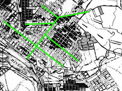
Richmond population distribution by race (1923)
09/13/2007 9:09 PM by John M
A detail from a 1923 City of Richmond Public Works map that upon which the darker areas “indicates location of colored population”.
The green indicates Broad Street, M Street, Venable Street, Fairmount Avenue, Nine Mile Road, and 25th Street. Click to view a larger image of the entire city.


Obviously I’m the only other person who finds this interesting, and very sad for the caption saying ‘indicates location of’ etc.
I say this given the lack of other comments.
Thanks, John, for posting it. I think it’s very thought provoking. I hope some other folks have some thoughts to post.
I can’t believe they made those poor black folk stand so close to each other.