RECENT COMMENTS
A fairly recent history
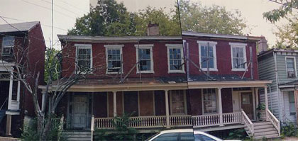
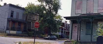
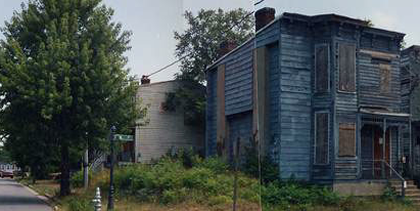
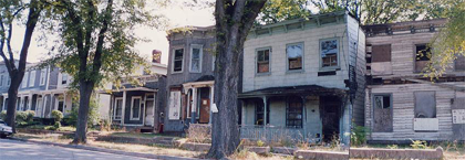
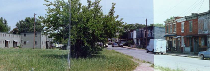
The Virginia Film Office has a location library of shots from around the neighborhood from what appears to be the early 1990s. The set labeled Church Hill Residential (Rough) caught a bunch of building that have since been fixed up or demolished.
Click any photo to see the full panorama…
These two photos from the same intersection on M Street show a different Union Hill.
The panorama of North 23rd Street shows the houses that used to be at 1001-1005, and shows the store that was at 1097 North 23rd Street. Fairmount still has a fair amount of decay.
The panorama of the 1200 block of North 22nd Street took me a little while to recognize, I had to walk over and get evidence to finally convince myself that this was actually the same block.
This shot shows the blank field where the new BHC houses on 26th Street have been built, and the old apartments across the street.
TAGGED: 22nd Street, 23rd Street, 26th Street, Fairmount, historic photos, M Street, panorama, Union Hill, Virginia Film


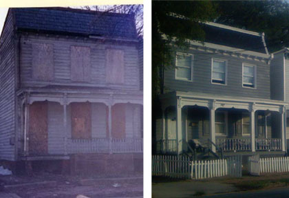
I found some more very interesting photos on the same site, in a set called “The Slums of Richmond, Virginia“. Two interesting finds there include a neat photo of a block of Venable Street and an *amazing* photo of Carrington and P Streets that has 2 houses that are now gone (including the house that used to be on that big triangle between 21st and 22nd!).
I’ve put a bunch of these photos into the flickr pool.
John, those are wonderful photos. I have to wonder, my former next door neighbor Ani Lytle used to take potential location shots for film productions, wonder if she took any of them….not that it would matter if she did or not, just an idle curiosity type of thing. Thanks for posting them!
I own a couple of books of photos (and commentary) about historic Richmond architecture, done in the fifties/sixties, by Mary Wingfield Scott and one that was edited by Louise Catterall – but I’m not aware of any body of work that continues into the 1990’s. Particularly interesting since these appear to be panorama type shots, which were not done back in the earlier books, but they do capture whole blocks well.
John, I finally went on the site – and they’re not labeled, hard to tell which streets are which. I could recognize a couple but that was all. (The Clay Street Market hasn’t changed much!)
Also, looking more closely, I realized they may be panoramic shots but they’re stitched together, not taken with a panoramic camera as I’d first thought.
If I had the time, it would be fun to try to label a bunch of them…
Wow, those pictures are crazy! I now live on the recently rebuilt 26th St. My house was the only surviving house on that block, though it appears to have been cut off in the one John posted above. The transformation is crazy!
The brick houses pictured in the top photo are 605/607 North 22nd Street. These were taken before I bought the properties in 1999. Wow, I have to agree with Magneto, the place looks entirely different today. Please note that the Skeleton of a Crepe Myrtle in front of 607 North 22nd Street miraculously came to life when I began to renovate the house. I planted a matching Crepe Myrtle in front of 605 North 22nd so they would grow together. However, the old root system kicked in on the one in front of 607 and is now 100 times bigger than the one in front of 605 North 22nd street. Strange happenings in Union Hill.
At one point, the building in the above photo was RibTown USA. That was back in 96-97 or so. I thought they had really good ribs.
hey magneto – didja look at the full panorama?
Mac, I agree, it was a BBQ and rib place right up until around 1999 or maybe even 2000, and it had wonderful ribs and BBQ and side dishes! The people who owned it left, I think someone told me one of the owners was in a terrible car accident, involved much hospital time and money etc.
To bad I was hoping to see my house in there. they have a picture of the church across the street with the house that is now a vacant lot next to it. This picture was taken from my front step it appears.
I’m glad someone was out taking pics during that time. I started taking my pics in 1997 and I could only do but so much with 24 exposures. I did get two or three pics from 23rd and 24th in Fairmount and a store that used to be in a triagle on Carrington.
The set of pics on that site doesn’t also shows Bryan and Redd Streets in Howard’s Grove. I did that area about a year ago and what a difference…
… and people wonder why I take pictures of neighborhoods…
Anyone know any history on the J.M Carter house @ 609 N. 25th? I can’t find anything on it!!
The Richmond Esthetic Survey at the Library of Virginia has an entry for James Monroe Carter house of 1855.
I’ve got a really cool aerial photo of Church Hill North that Mike Yengling, city staff gave me when we got our designation. It’a about 18 by 24 in dimensions and probably dates to the late 50’s/60’s.
You wouldn’t believe the difference. So many buildings have been demolished since then.
If someone has the tech savvy to scan this large of a photo, I’d be happy to contribute it to the photo archives here on this site.
Here’s my contact info if anyone can do that:
laura@mysterydinner.com
Union Hill was the first place A.C.O.R.N. held a “Sell-A-Bration” to bring people to the area and show the possibilities of renovation and rehabilitation. It was a sad looking area… but that was 7 or 8 years ago. We’ve come a long way.
Wow . . . these pictures reminded me of some poor times living in Church Hill; I rememember many of these ruined homes – I walked these steets and road bikes in most of these areas. I lived and had friends who lived in many of these houses. Needless to say these pictures brought tears to these weary eyes today. I am glad many of the neigborhoods are being revitalized – that’s a blessing. But, I must also add that although the buildings are being revitalized in many of the areas; many of the African Amercians living there moved away as soon as they could afford the move. And, although we were very poor back then, we did not face half of the issues that the young black youth who live in Church Hill face now. We may have been poor; but we had pride, and we loved our neighbors. I don’t see that with the youth anymore. . . I’m afraid for my son because we now live in Church Hill again. It’s so scary; it’s so sad. BTW, where do the white children go to school who live in Church Hill? Perhaps my next investment will be transferring to whereever that is(although it will leave me with no personal luxuries I’m sure); because he certainly can’t learn at the school he’s attending now – the only public highschool in Church Hill.
I suppose enough tears and rambling for today . . . It just brought back memories of better days . . . when the corner stores were owned by our neighbors . . and all respected all…
Anyone remember EDloe’s pharmacy 26 & P street,O B’s Grill & Boys Club(700 block 25th Street),Orange Front Store 28th & N street,J Andrew Bowler School (600 N 26th Street),East End Theater(400 Block North 25th Street),Mr.Lonnie’s snow cones,Bridge that started at Princess Park and traveled to then MCV/EG Williams hospital ( Walked that bridge often going to Lowes & Capital Theater on East Broad Street),Feeding the birds at Capital Square.,Ikes Shrimp House(31st & P Street) Those were the days..
Carolyn, I remember all that girlfriend! Those were the days!!! If any one has any pics of that bridge that started at Princess Ann Park and traveled to MCV (We called it the Vadoc) I’ld love to see them. Nice memories, Carolyn. Took me waaaaaaaaay back! LoL 🙂 Peace, Light and Love to you and yours. . C.
For anyone interested, the original Film Office links in the top and post#1 from 2007, have changed. They are now here (their site can be confusing):
Church Hill (Rough):
http://va.reel-scout.com/loc_detail.aspx?id=77&g=&cid=9
Richmond- Distressed Area:
http://va.reel-scout.com/loc_detail.aspx?id=3942&g=&cid=9
Hey carolyn i remember orange front store on 28 street i lived on 27 street.I also remember that bridge my mother walked it a lot to take us to mcv.
I went to bowler and george mason my teacher at george mason was name miss simpson
I also grew up in Church Hill near Cedar St. Church. I recognize all of houses in these pics from childhood memories. I remember walking to George Mason and Mosby Middle school, walking field trips to St. John’s church, riding bikes during summer to cimborazo pool, to jefferson park, to the 25th st library, to siegel’s for my granny (God rest her soul. She lived on 24th st for 40+ years). My mother and I used to walk to what seemed like every church in church hill and to the thrift shop that used to be beside the post office on 25th street. Riding thru my old ‘hood, its amazing to see the changes and renovation but the most drastic yet remarkable change is the diversity. Its good to see those sad old houses get some luv and become homes for some kids who can grow up with good memories (no it wasn’t the best neighborhood to grow up in by any means but it wasn’t the worse either)