RECENT COMMENTS
Eric S. Huffstutler on What is up with the Church Hill Post Office?
Eric S. Huffstutler on What is up with the Church Hill Post Office?
Yvette Cannon on What is up with the Church Hill Post Office?
crd on Power Outage on the Hill
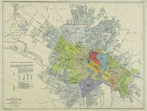
Map showing territorial growth of Richmond
01/13/2009 11:10 PM by John M
The Library of Virginia offers for sale a beautiful print of a 1923 map from the Department of Public Works called Map showing territorial growth of Richmond. The hand-drawn map shows the 9 separate annexations that occurred after Richmond was incorporated in 1742 and before 1923.
In looking at the larger version, I see that Pink Street at Carrington is labeled as Pike Street. Cedar Street is still Pleasants, too – anybody know when/why that was changed? Government Road is called National Cemetery Road, Jennie Scher is Old Mill Road, Fairmount is still S Street, and Union Hill has a Pickett Street.


There is a Streets Book on the 6th floor Survey Counter of City Hall listing many street name history facts. I am fairly sure you can find out the exact date of Pleasants’ Street in there.
That sounds cool, thanks!
most excellent groovy.
Definitely a nice map. There was a guy who was supposed to give me a map like that. I wonder if it was that one? Anyway, I have a neat big map of Richmond from 1890 I was just given. This city’s gone through some changes, but then you’ll see we hadn’t changed that much.
Holy cow. I thought that map looked familiar – I have an original on my office wall!
Pickett Street and Scott Street were in front of my properties at 2108 East Leigh Street and 2110 East Leigh Street. These were the streets before Leigh Street cut through. I believe 2108 E Leigh Street faced Pickett and 2110 faced Scott.
Both 2110 and 2108 East Leigh Street homes were picked up and turned to face the new Leigh Street.
I remember seeing this somewhere, but do not remember where– any ideas?