RECENT COMMENTS
Eric S. Huffstutler on What is up with the Church Hill Post Office?
lanny on then it happens to you...
JessOfRVA on then it happens to you...
Becky Metzler on Updated! Guess what's happening on Mosby/Venable?
Mary on then it happens to you...
Sid on then it happens to you...
Becky Metzler on Church Hill Startup Tackles Insurance for Freelancers
A noteworthy spot on the map…
07/05/2009 9:59 AM by John M
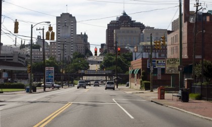
PHOTO: US 250’s Eastern End by Synthetic Dreamer
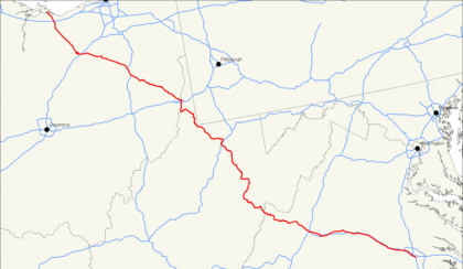
The intersection of 18th and Broad Streets is the eastern terminus of U.S. Route 250. From here, U.S. Route 250 meanders 514 miles (827 km) west and north through Virginia and West Virginia to end in Sandusky, Ohio. Broad Street east of this intersection is merely a portion of U.S. Route 60
Map of U.S. Route 250


This fact should be publicized and celebrated. Maybe we can work out something with Sandusky as a sister city and call this the relationship The Axis of Something.
Well, Sandusky is the roller coaster capital of the world. I spent a very nice afternoon last summer drawing on the bay while my nephews ran amok on the rides.
Gabriel was hung at this intersection
The marker for that is few blocks west on Broad, past the train bridge.
Gabriel Prosser Slave Revolt
http://chss.montclair.edu/english/furr/spl/gabrielrevolt.html
I had sent an email to the DPW about an “END US 250” sign being put up here back in March. They said they would, but they haven’t yet. It seems silly that there isn’t one here when there is one at the other end in Sandusky.
Thanks for using my photo. 😀
@ Will W. I work for DPW I have forwarded this information to the traffic divisions director of ops. I will update once I hear back.
@john, yeah I’ve seen the marker but i also read in a book that Gabriel was hung at the intersection of broad and 18th. Was anyone around when this happened and can give us the exact location?
Everything that I’ve read says that he was hung at the city gallows. Last year’s report by DHR (PDF) says that “the preponderance of evidence from available sources indicates that the Burial Ground and gallows are located under the north and south bound lanes of Interstate 95.”
@D.H. Thanks! 😀
The old city map that most refer to as showing the burial ground, gallows and an armory were all at the current site of the VCU parking lot on the north side of broad. From the map overlays I’ve seen, it’s possible that the gallows site is located now under I-95, but not certain.
The Virginia Historical Society worked up some interesting topographical maps of that area.
Like John, I’ve never seen any map or other record to indicate that the gallows were at Broad and 18th.
In fact, at this point in the city’s history “Broad Street”, I seem to recall,was not a contiguous roadway, with a break that occurred right about where Shockoe Creek cut through (the gallows/slave burial ground on old city maps is on the west side of Shockoe Creek. At the time of Gabriel’s hanging, from what I’ve read and heard from historians, only a narrow foot bridge across the creek connected the two sides of Broad.