
RECENT COMMENTS

Photographs of old Fulton
I read Selden Richardson’s Built by Blacks in late 2006. This sent me off to find out if his descriptions of Evergreen Cemetery were accurate, to see it for myself: Evergreen is everything that he described and more. This medieval cemetery was my takeaway, but another recent read has sent me back to Richardson’s amazing book and the chapter on the urban renewal that has all but erased the original Fulton from the map of Richmond.
My first exposure to the tale of the demolition of Fulton didn’t really stick. At the time it was more difficult for me to imagine that the city and federal governments, through neglect and demolition, would conspire to take apart an entire community. The lack of almost all visual references hides that the area has any history at all, and the story of old Fulton didn’t really sink in.
A recent tip led me to pick up Scott Davis’ The World of Patience Gromes: Making and Unmaking a Black Community (1988), and this book and it’s people made that Fulton real to me. I was surprised to find in a recent re-read of Richardson’s book that he references Patience Gromes repeatedly; I don’t know how I didn’t follow this up at the time. After reading Patience Gromes, I really wanted to be able to see this Fulton that was being described.

Richmond Then and Now’s archive of Times-Dispatch articles about Fulton show some of the story of the demolition of Fulton, but don’t really show the community before.

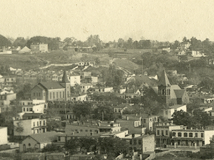
A 1935 print by Charles W. Smith, Fulton from Church Hill, tantilizingly shows a dense urban neighborhood, on a regular street grid, with rows of houses and a large central church.

With limited resources available online, I paid a visit to the Valentine Richmond History Center for a look in their archives. I was hoping to find photos of Fulton that would let me see it in the context of Richmond’s neighborhoods that still survive, to maybe see in Union Hill, Oregon Hill or the Fan echoes of the streets of Fulton that are so different now. I found a few resources at the Valentine, and was able to get a few scanned to share out.
All of the images below credited to “Valentine” are from the Cook Collection, Valentine Richmond History Center. All rights to the images are reserved by Valentine Richmond History Center. The photos are arranged oldest to newest as best I can tell. Click to view a larger version if available.

The amazing aerial photo puts authentic detail to the church and row houses of Smith’s 1935 print. The baseball game underway in the center and the horse & carriage in the bottom left corner hint at the life in the community. Looking at the larger version, I feel like if I look long enough, more people will start moving across the photo. Of the images of Fulton that I’ve found, it is one of the few (see also) from before the urban renewal period — almost every other photo was taken later to illustrate decrepitness and decay.

This 1961 photo of the corner of Erin and Nicholson is from a later Richmond Times-Dispatch article. It was used to illustrate “the dilapidated homes” in the area.

These boarded-up Fulton Street storefronts are immediately reminiscent of Main Street in Shockoe Bottom or Hull Street in Manchester.


This could be Venable Street between 21st and Mosby today.


Government Road crosses left-to-right across the top of the photo, the train tracks are at the far right. The former trolley barn, still existent, can be seen just off center at the top.

The 2nd of the two aerial photos above shows the houses just about right up on the James River. Some of this part of the street grid is the same, though the bulk of the neighborhood (and Gillies Creek) has been redrawn as you can see in the 2 maps below.
")

Thank you for posting these. I’ve only been in RIC for 4 years so this was before my time. It always feels a little strange to drive through Fulton knowing a whole village existed there isn’t, anymore.
I guess the good news is, this didn’t happen to Church Hill.
A similar fate was planned for the Fan District, which had seen a terrible decline in the 1950s. The “wisdom” of tearing down instead of fixing up will never die as long as our legislators are brainwashed by developers who promise everything and deliver… not so much…
Wow!! I am going to be up all night reading these posts! I want to know more about Evergreen Cemetary!
These are fantastic photographs, thanks for sharing!
And a small bit of credit goes to Margaret Freund for what she has done to save and constructively reuse the Fulton School.
Thanks for posting – illuminating and sad.
How are they getting away with building those plastic suburb style houses to this day? The neighborhood over by Gillies is horrible looking. If anything needs to be demolished it’s that. There is no sense of community to it. They had a chance to create something great even after screwing it up and they screwed it up even worse. Unbelievable.
There is a terrible irony that the town of Fulton has been replaced with the failed architecture of suburbia and the dying car culture. Whoever the planner was for this exercise should be embarrassed and ashamed.
The destruction of Fulton is one the most dastardly action of the City of Richmond. It almost happened to Church Hill. Thank God they finally woke up.
Thanks for the photos…so many wonderful memories growing up in Fulton. Those pictures of storefronts arent on Fulton though…Either Williamsburg Ave. or Lousiana St..im very sure of it.. I lived on Fulton Street back in the late 60’s
Does anyone have any pictures of the the old Webster Davis Elementary School? thats the school that the blacks in Fulton bottom attended before Nixon desegregated the schools
I have several drawings of the old Fulton that I did in the 60’s and early 70s (when it was being torn down)… I lived on Fulton Hill during those days and spent a lot of time down the hill as Fulton was being wiped out… If you are interested in the copies of my drawings, let me know…
I once lived in Fulton before i moved to Washington DC. I wish that I could find some of the people that lived there. Such people as Barbara Ann Woodson, Bobby Pearson and his brother Melvin. In addition to his mom Irene Pearson. I can also remember Ray Hockayday . I never forgot these people. I,m sure they don’t feel the same way. I also can remember our 5th and 6th grade teacher Mr Kemp that was our elementary school teacher at Webster Davis School. I can remember the day when President Kennedy was killed. We were in the trailer on that particular day.
I would also like to find my best friend named Thelma johnson that lived in Fulton at the time.
Ms. Francine,
You might have luck finding your old friends if you stopped by the Neighborhood Resource Center http://www.nrccafe.org/ They are very involved in the community and might know some of your friends, if your friends are still in the area. Also, the Powhatan Community Center might know of them, and of course the local churches in Fulton also.
Hey Francine..how are you..missed you so much..are you on facebook??? whats your email addy??? of course we remeber you,,i hope you come back here soon so we can talk.. look for me on facebook at melvin t pearson.. love you my dear sister//
Mr. Harrison, My mfamily came from Fulton, thaeir last names were McCabe and Slater..The McCabes resided on Louisana St, and the Slaters on Fulton St.My GF was a McCabe and my GM was a Slater. Anyway I’m very interested in your drawings. Please contact me at the e-mail address at the top. Thank You
Gene McCabe #24, it appears that your email address did not make it into your posting. When you post here, your email is not published. If you really want it published, then you will have to put it in the body of your posting.
my grand mother came from fulton, i visited state st cousins.. sweets/hendersons i will look them up
I WAS RAISED IN Fulton Bottom. 1006 Lewis
Street. The Street does not exist. Thanks to the
RRHA. I GRADUATED Armstrong High Class
of 1957. Attended College and went on to
CUNYCITY COLLEGE OF NEW YORK.
VERY BITTER MEMORIES OF FULTON.
EVEN THE COACHES AT ARMSTRONG
HIGH WOULDNOT GIVE FULTON ATHLETIC RECOMMENDATIONS, EVEN THOUGH WE
WERE STARTERS. MY RECOMMENATION
CAMES FROM FRIENDS I KNEW AT MAGGIE L.
WALKER HIGH SCHOOL. WEBSTER
DAVIS ELEMENTARY SCHOOL DOES NOT
EXIST, NEITHER DOES J. AN DREW BOWLER.
ARMSTRONG HAS M OVED OVER TO COOL
LANE THE OLD JOHN F.KENNEDY HIGH
SCHOOL. MY MENTORS WERE ALL JEWISH
FRIENDS FROM NEW YORK THEY HELPED
ME GET A JOB AND EDUCTION IN N.Y.C.
EVERGREEN CEMENTARY IS AN ASTROCITY
TO OUR ANCESTORS. SHAME ON THE RRHA
AUTHORITY. I LIVE IN Richmond, but
identify New York as my hometown. I LIVED
IN CHARLOTTE,N.C., N.Y.C. WILMIGTON,
DELAWARE. RICHMOND IS 20 YEARS
BEHIND DEVELOPMENT. SHAME,SHAME.
Mr. Jeffries, althoug I was born one year before you graduated from Armstrong, I feel your pain. I grew up in Creighton Court. In the early ’60’s, I use to visit Fulton with a family (The Merrittes) who had relatives living there. I heard those stories of how Maxie Robinson didn’t give the guys from “the projects” (Creighton, Fairfield, Mosby) and Fulton a chance as he did with the guys from Southside…eventhough we had the better ball players in quarterbacks and running backs. However, I disagree with your position as to “your hometown” being in New York, but that’s your perogative. My opinion, your hometown is where you were born and raised at…not where you “grazed” at. No matter what city I ended up in, I will always consider Richmond, Va. via Creighton Court my hometown. But thanks for sharing.
My mother was born and raised in Old Fulton (Inez). She always looked so sad when late in her life there was no trace of her community to show us. I appreciate these pictures and information on this site. I am going to share this with my family.
This is very interesting. Before I found your article and photos I read an article to my friend (who is legally blind) who grew up in Fulton during the 50’s. She was appalled with the inaccurate manner the information was depicted. Your view is in line with what she remembered. I wish you could speak to her and others that lived in a Black neighborhood that was self sufficient.
@31 Emma, I’ve got a friend who was a social worker for the city, she’s now retired at age 72, but she used to tell me how self-sufficient Fulton was back in the day. I don’t know if anyone is doing any oral history of the area, but perhaps John Murden, who moderates this blog, might consider it. Or maybe he could find someone else who used to live there to help with an oral or written history project….in looking back at these posts it seems that every so often, someone comes in and says they used to live there.
My family has lived in Fulton since at least 1910, my mother , who is 92 today ( 4/24/15 ), and well aware of the atrocities committed by the white politicians and the absolute neglect of the slum lords, who served on City Council as well.
The destruction of my beloved and nurturing community is the great pain of my life. I will never forgive the city for the racist acts then, and the lack of accepting responsibility to this day. Is it so hard to say, we as a community of Richmonders, screwed up and got it wrong from the very beginning.
When the RRHA was formed by the city, they had no clue as to what to do, all they knew was, they had millions of dollars coming from HUD, and it had to spent on urban renewal.
They have has leader after leader, and mis management at RRHA, since day 1.
They just recently fired another Director of RRHA, because she couldn’t deliver, just as her predecessors. Corruption, taking trips to casinos, in the name of urban renewal and other forms corruption have existed since Frederick Faye took office.
One of the first hires for the Fulton Ad Hoc Committe, was a convicted felon, just released from prison.
If anyone want to discuss any matters on my beloved community, you can drop me a line….I welcome any positive feedback and negative feedback as well.
I don’t think any of you , who has never walked in our shoes, to see your whole world, completely wiped from the face of the earth, in the name of renewal, and being a political pawn, for the first black mayor. I have no respect for him at all. He sold my community, lock stock and barrel…..with the help of a few insiders……..
Mr. Beverly, you might be interested in the Fulton Oral History Project, as told by some of Fulton’s residents:
http://chpn.net/news/2015/04/15/vcu-now-streaming-historic-fulton-oral-history-project_41748/
My family also has history, if not roots, that are “beloved of the Fulton District of Richmond, Virginia”.
My daddy was born in North Carolina, of Ethiopian heritage, before my grandparents and family members relocated to Fulton. My “momma” was born on a Native American reservation in Charles City, County before she was later relocated along with other family members to the the Fulton District. Momma was over 100 years old when she passed.
Much of what I learned about family heritage as a child growing up in Fulton came from word of mouth, what was written in an 2 old family bibles and old photographs.
Fulton seemed to have been one of the ” catch all’s” for people of color (we now refer to ourselves as black, as we “say-it-louder”) who relocated to Richmond in Virginia. I also consider the Fulton District of Richmond, Va. to be my old home town.
As I recall matters, it was a major fire and later major flooding that helped contribute to many of Fulton’s homes being demolished, not just the negligence of RRHA’s bad distribution of federal funds, or the manner in which the City and State Government Leaders certainly seemed as though they may not have cared. Some old residents moved to Fulton Hill.
Even though my mother walked picket lines in protest against racial injustices; even though as a young male I was apart of an NAACP Adhoc Committee reaching out to quell violence in 1968, I should have never allowed my mind nor my heart to be moved away from my childhood home town. It also takes a collective of positive minds within a “small village” like Fulton, not just money, to cause positive changes to come about. I for one should have been a part of that collective of minds asking government to rethink and make better choices in Fulton. Yes! …, I too believe it was a very bad choice to demolish and scatter Fulton Bottom homes to the winds, but this is hindsight.
I also grew up in Fulton and agree with all you have said.
I went to a party this weekend and actually met someone that had attended Robert Fulton. I could not believe it. So rare to actually met someone who knows anything about Robert Fulton and the history of the school. I began in kindergarten. Mrs. Gennings (spelling may be wrong) was my teacher. I had her for the 1st grade too. My experience there was so very positive. I remember walking up the steps and students would look down at the ones coming up. The boys were terrible at spitting at the girls as they walked up the steps. There was a set of monkey bars on the playground that was shaped in a rocket. I fell off of them and had to get stitches in my chin. The fire department right there on Williamsburg Rd use to sell candy. Walking home we would stop and the fire fighters would sell us the candy. Then when I was approaching the 3rd grade (I think) that is when the older classes were sent down the hill to Webster Davis and the younger classes from Webster Davis came up to hill to Robert Fulton. They had to “mix us up.” Remember busing? Again, at Webster Davis, my experiences were very positive. I remember the parents had more issues with the change than the kids did. My classmates were so very special. I remember, across from Webster Davis, there was the very best little store. We would go into that store after school and buy penny candy. Remember, 25 cents would get you 25 pieces of candy. They also sold guppies (fish). We would buy two take them home and before you knew it, you had an entire tank of guppy fish. My parents would get so mad. I remember the row houses. Now when I drive down there – nothing looks the same. It really is sad when “progress” wipes entire communities off the map. So very sad. But my memories are very special and no one can wipe them off the map!
I grew up in Fulton on State Street in the 700 block. One of my fondest memories is of the Bethlehem Center. I learned about wood working form Mr. Christian. He also coached football, baseball and basketball there. I remember making a squirrel lamps in the carpenters shop in the center. I also remember a Mr, Faris (the spelling of his name may not be correct), Ms. Bears (SP) and a Ms. Myers. The building was an aluminium simi-circle building in the 10 hundred block of State St. I attended Webster Davis and my uncle was the custodian there. The book by Scott Davis’ The World of Patience Gromes: Making and Unmaking a Black Community (1988) was about my grandmother. She was the main character in the first half of the book. By the time Mr. Davis got to Fulton, I was off to college, Norfolk State. i finished there and moved to PA, retired and now I am an adjunct professor at a local community college in Harrisburg.
Mr. William ‘Bill” Christian tough me things that I still use today. I know he is gone now, but I would like to thank him and his family (I know he spent many days and evening away form them) teaching and coaching others like me.
Yes, Fulton is gone now, as I once knew it, but I do have fond memories of growing up there.
CER of State St.
Fulton gave me the foundation for my having a career on the ” “Broadway”stage. I first wanted to dance in the first grade at Webster Davis elementary school, not many schools offered dance during that time but mine did. I did not get to dance as a kid but sing I did do. Thank you Fulton!
I lived on Garber Street and walked to Robert Fulton (’56 to 61)passed the crossing guard and remember in my dreams the pagents, paper drives, classical music in cafeteria, busing to Richmond Symphony, Mrs. Garthwright’s resource classes and Mayday in front of the great columns in front. We sledded down Powhatan Hill and shopped in Fulton bottom until they bussed us to Chandler and John Marshall. That was and will always be community to me.
I grew up in Fulton and lived there from 1946 to 1958. I attended Webster Davis Elementary School and went to Madison Temple Church. Mr. Kemp, Mrs Webstray, Mrs. Braxton, Miss Hubbard were a few of my teachers.
It is a shame what happened to Fulton and the surrounding area.
My grandmother’s house on Government Road near the railroad tracks was torn down, as well as the other houses in the area. Thank goodness my grandparents had passed on before this happened. All in the name of so-called progress.
All those homes needed was a little TLC. It would cost a small fortune to build them now.
I remember passing Evergreen Cemetery on the way to Oakwood, and Mama said it was the black cemetery and we thought it was awful it was allowed to go to pieces.
In recent years, I learned why. It was a private cemetery and apparently it got to the point where there were no family members left to take care of the graves or family members moved out of the area.
I was born in 49 and we lived on Louisiana St along with many kin in the same block. Harlow’s, Profitt’s, Butler’s and Johnson’s?. There was a store on the corner with the road beside it going up the hill to the front of Robert Fulton. I could go across the street to grannies next door to the store and look up the hill to the school and think I would be go someday. In 54 I went to live with my Aunt and Uncle on Farrand and did go to Fulton till we moved later moved to Varina in 58. My grandparents and many kin still lived there for years afterwards and I visited the area often. Loved the the area and the stores, we would return to the “bottom” to grocery shop and buy gas among other things for years afterwards. I was surprised when I came home after growing up, marrying, moving away and those beautiful old well made homes were gone, replaced later with cookie cutter cheap houses. Sad to think of the loss of some of those beautiful structure’s having been bulldozed and destroyed.
A lot of fine people lived in Fulton, and one of them was the McCabes. My grandmother live at 703 Louisanna until her death in the late 1930’s. Her name was Grace McCabe. It’s a shame to have seen this place go, and now at present they are rebuilding!I wonder if the closeness will return or will it just be people living there! If anyone cares to reply do so at GMcCabe38@aol.com
Hey Ms. Francine #13- Ray Hockaday lives at the corner of n. 27th and E. Leigh st.! Great guy!