
RECENT COMMENTS
Eric S. Huffstutler on What is up with the Church Hill Post Office?
Eric S. Huffstutler on What is up with the Church Hill Post Office?
Yvette Cannon on What is up with the Church Hill Post Office?
crd on Power Outage on the Hill

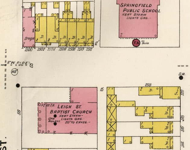
Sanborn maps for Richmond 1905
02/05/2011 4:15 PM by John M
The 1905 Sanborn Maps for Richmond are now available online:
Sanborn Maps were originally created for assessing fire insurance liability in urbanized areas in the United States. The maps include detailed information regarding town and building information in approximately 12,000 U.S. towns and cities from 1867 to 1970.

I was told my home was 1910. It is clearly 1905 or earlier! Thanks, John.
Wow, thank you for posting! This map solved a mystery for us.
Do share!
Thanks John! As always, great stuff!
I feel Richmond got lazy and stopped naming the alphabetical streets. Maybe they should get renamed? I still don’t like how Cedar Street Baptist hijacked 3 separate streets and renamed them. You didn’t see 5th Street Baptist renaming 3rd Avenue. 10th Street Baptist didn’t rename Fairmount. If they want, just keep the blocks between 23rd and 25th Cedar Street and return 19th and Pleasants. Anyway, M. could not be Mason anymore since Mason is over southside and N. can’t be Nelson because of Fulton Hill’s Nelson. There’s no Otis, Pendleton, or Quince. I’m not sure if R through T had names. But I think T could be the new Tate St and Tate could be renamed Z or whatever Z name.
Which map corresponds with 51? I flipped through all of the LoC pages and couldn’t find my block.
I think these two: 62 & 63
Restoring those street names is in no way worth offending Cedar Street Baptist. Theirs is now a history worth preserving.
re: #5 I read recently that Grace Streets used to be named G Street. The switch to Grace supposedly was influenced by the number of churches being built along it.
this is fascinating but i’m having trouble navigating. i’m looking for the page (map?) that contains info for the blue 35 “block”. how do i correlate the block number to the map images?
I found that the pages and the maps were off by about 10, so image #45 correlates to block 35.
@#5, I could be wrong, but I believe the renaming of Pleasants Street predated CSBC’s move to its present location.
I did a lot of research on that part of Union Hill a few years ago. If you’re interested, I’d be happy to go back through my research and see what I can find.
John, thanks for posting this link! I spent part of yesterday afternoon prying a section of the foundation of 709-707 N.23rd Street out of one of my flower beds. Those two addresses, which were a double house, disappeared sometime between the 1905 and the 1911 or 1920 (can’t remember exact date now) Sanborn maps.
thanks for your help, john. one more question—have the house numbers changed since this map? they don’t seem to correspond with some of the buildings that existed then and exist now.
Lora, I remember when that whole stretech was renamed. Cedar Street had been there for a long time on N St.
Houdon they shouldn’t be offended. they forced map makers to rename 3 streets for their own vanity.
Was there a Washington Street up on Church Hill? I’m having difficulty finding it and know that it existed (my great great grandfather lived on it and I know it was on the Hill).
very cool, thanks for posting – neat to see the actual names of the “letter” streets
PTG… You can’t go by what the Assessor’s office says the age of a house is unless it was historical. During the depression, there was no real assessor’s office and they sent people out to inventory houses and buildings. If a built year was know, it was entered in the books. If not, a “best guess” was done and you will see a TON of houses listed as 1910 on the books. I know houses built anywhere from the 1840s-1880s are often listed as 1910… so that is where doing some personal research digging in various maps, city directories, and land deed books come in handy to zero in on a house’s age.
Eric
Eric, where are some of the best places you’ve found to begin to search the history of a house?
Thanks Eric; yeah, we had hear about the “1910” guesstimates recently. I would love to find the actual age, so I’ll just have get to that research (any good resources from anyone are welcome!)
Eric,
From what I understand the date of 1910 occurs so often because property records had been destroyed in a fire. When the homes were recorded again they used the year 1910 across the board – the year they compiled their data.
And yes! I’ve found the Richmond courthouse deed books to be the best resource and excellent in tracing the history of the precious owners. In micro films of the old deeds you’ll find them all hand written and in some cases the wills of those who passed the property along to their family are hand written as well. Each deed is traceable back to the previous one by the number of the deed book and page number.
I traced it the last house I looked up and the families back to the land purchase in 1802. It was all right there.
“previous” oops 🙂
Exactly Eric S. Huffstutler. I still have no idea how old my house is. All I know is that it is 96 years old as of January 27 because my great aunt was born here. I also know that the city directory for 1914 had the house vacant but someone living here between 1910 and 1913. I never got to see any prior to 1910. The city has the house being built in 1910 but I think it might be a little older. I really can’t tell. We only have 3 deeds, one being 1912, with no mention improvements, only land. A 1901 map doesn’t show anything on the lot. I wish I knew who built these houses or that there was a record.
Rob, Washington Street used to be where MLK School is.
These old maps are amazing. Someday, when I’m a retired old lady, I’ll research the decision to name the 2-blocks along the northern boundary of Jefferson Park: Princess Anne Avenue. I’ve always felt the name was ludicrous. Why not just call it E. Leigh Street? If anyone has any dirt on this street’s naming, please share.
@Elaine, if I had to guess, I’d say it’s named after the extinct Princess Anne County, Virginia, now known as Virginia Beach. Just like in D.C. where many of the avenues are named after the states, a lot of the streets around Richmond are named after Virginia counties, particularly in the northside and around Byrd Park (Nelson, Nottoway, Appomattox, etc.).
This practice must have fallen out of fashion, because to my knowledge there is no Virginia Beach Street in Richmond and Princess Anne has been extinct since the early 60s.
More blog posts like this please!
My house has a plaque on it and says it was built in 1859, however, one of the maps John posted on here a bit ago (I think it was an 1867 map?) only shows 2 houses on my block. Are the house plaques 100% accurate?
Like maps? Here are all of the CHPN posts with maps /tag/map/
If youre looking for house history, you might like this one too: /2009/11/29/who-lived-in-your-house_10930/
Thanks to the post above, I checked out the Hill Directories a few months ago and learned some interesting stuff about our house.
So what is up with the house plaques? The wooden ones that list a name, their occupation and date the house was built. Are they sanctioned by a historical society or something of that nature? Or did homeowners just put them up on their own accord at some point?
In 1982 Historic Richmond Foundation purchased a large group of houses north of Broad Street from Stanley Smith.They resold them to individuals for renovation. Many of those were documented and the plaques were put up then. Some similar plaques were put on houses which were not in that group about the same time.I had one on a house that I bought, and, after research, found that the date was off by at least five years. I have found that a good starting point is the City Directories at the Valentine Richmond History Center library. After that, as Eric said, doing a chain of title search is the best tool at the John Marshall Courts Building (basement level). If the house was north of Broad in Union Hill or out farther toward Nine Mile Road it was in Henrico County until 1906 and you would have to go to the Henrico County Court House.
I called the Henrico Co. court house last summer when I began my research and they said all of the records are at the Richmond court house now. My house on 26th near M was in Henrico Co. prior to the civil war. The Henrico county land records (titles) were on micro film and the record books were at the Richmond Court house. They’ve done a great job of cataloging the transition.
When I did my house and actually most Woodville properties in 2000, my research began in the city and after a point I had to go to Henrico. All of our deeds were in Henrico. So they’ve shared deeds with the city now? I think it would be better to be able to go to either location for former Henrico properties.
Sorry to be late coming back but one source, like our friend Bill said, are city directories. Not the telephone books but the Hill and Polk kind. If you think the house is older than Civil War, I would first start with the Mutual Assurance insurance records. then maps such as Beers or Sanborn. The deeds as also mentioned located on microfilm at the State Library in the Genealogy area. The various census records too starting basically with 1900 will have the street names written in on the border. And any inventories taken, if the house was of some special or historical interest, may have been inventoried during the 1936 WPA project and on the digital holdings at the State Library. Old newspapers too may hold clues especially if the house was for sale, rent, or even property transfers. More and more are coming online at the Library of Congress and Genealogy Bank as well as the Civil War Richmond Daily Dispatch linked at University of Richmond. Those are a few places to look. Didn’t say it was easy or quick but if you are sincere in wanting to zero in on the age of your home, these are a few tools.
Eric
Clay…
I will almost bet money that those wooden plaques were on houses purchased by Dan Harrington during the mid 1980s when properties were boarded up and selling dirt cheap. He bought up several to restore. Our house, the one he selected for himself to live in and the oldest, has one too. I am not sure if he had access to everything and knows the house was built an exact year. That is where you need to do some researching yourself like you did finding out your house wasn’t on the block on a certain year map.
Eric