RECENT COMMENTS
Gustavo S. on Missing this fella? Updated!
Eric S. Huffstutler on New sidewalk at Clay and 26th Streets
Eric S. Huffstutler on Missing this fella? Updated!
Eric S. Huffstutler on Old water tower is coming down
Eric S. Huffstutler on then it happens to you...
Eric S. Huffstutler on What is up with the Church Hill Post Office?

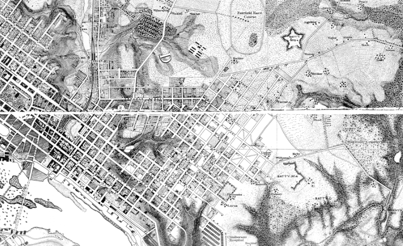
U.S. Army Corps of Engineers map of Richmond (1867)
08/14/2011 12:03 PM by John M
From the 1867 U.S. Army Corps of Engineers Map of Richmond, made under the direction of Maj. Nathaniel Micheler and Capt. Peter S. Michie (National Archives, Record Group 77, Map G 204, #55 & 57). Via Civil War Richmond:
This map is scanned from a reprinted map published by the Richmond Civil War Centennial Committee in 1965 (Official Publication #25). The map was completed in 1867, and shows the city of Richmond as it appeared shortly after the Union occupation of Richmond, in April of 1865. It is, in my opinion, the most detailed and accurate map of the city to be found.
TAGGED: map


I had copied out the panels, pieced them together, and hung it in my old cubicle at work. Since I draw maps, people thought I had drawn it. There’s more to the map that’s not shown here. I’d like to see the whole thing. I know there’s a section showing Manchester and Tree Hill Farm as well. I tried to contact Mike Gorman about the map but he never got back to me.
@Cadeho – There’s a large framed version of the complete map hanging at The Roosevelt at 25th and M Streets.
Seeing it there made me realize that it was not among all of the maps that I’ve posted here over the years.
Nice! Thanks. I wonder where I could buy one?