
RECENT COMMENTS

When the streets had no names
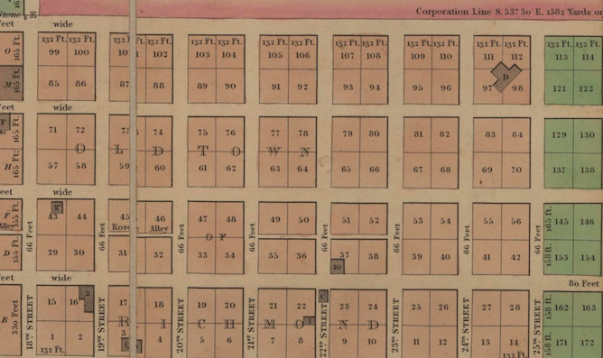
ABOVE: Plan of the city of Richmond drawn from actual survey and regional plans / Bates, Micajah. [1835] (DETAIL)
There is one glaring omission on the very early maps of Richmond: no street names. Going back to the 1736 map known as the Byrd Plan, there are no streets names listed on Richmond maps as late as 1798.
Early Richmonders likely described their houses or mentioned well known landmarks to visitors. That is exactly what was done by agents writing up fire insurance policies at this time. A policy purchased by Richard Adams, one of the main landowners in Church Hill, in 1796, describes Adams’ home as being on the “mane street leading to Rockets on the south.” Another 1796 policy simply lists present-day East Broad Street as the “main street running west past the Swan Tavern.”
By 1780, a few of the north-south streets had been numbered, but that was all. As Richmond grew, and especially after it became the capital in 1780, this was no longer practical. That year, the Directors of Public Buildings (which included Thomas Jefferson) met and passed resolutions naming some Richmond streets and alleys, mainly ones near the river and in the Rocketts area.
The numbered streets, which had previously had present-day 25th Street as First Street, and increased in number going westward, were flipped, and 25th Street became 25th Street. It wasn’t until 1808 that resolutions were passed naming the east-west streets, starting with A Street and ending with L Street. A Street was Arch Street; B was Byrd Street; C Street was Canal Street; D Street was Cary Street; E Street was Main Street; F Street was Franklin Street; G Street was Giles Street, which was changed to Grace; H Street was Broad Street; I Street was Marshall Street; K Street was Clay Street; and L Street was Leigh. Letters were added as the city grew.
By 1839, people were complaining about the street names being confusing, especially as Richmonders evidently used different names for the same streets. Broad Street was called “Main Street in Shockoe Hill” but E Street was also already being called “Main Street.” In 1844, the Directors finally gave the streets the names that most of them still have today.
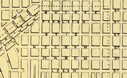
Streets added north of Leigh Street, however, still retain their lettered names, although the city briefly tried alternate names, east of 25th Street only. On a map drawn by F. Geese in 1876, M Street was Mason Street; N Street was Nelson Street; O Street was Otis Street; P Street was Pendleton Street ; and Q Street was Quince Street. By 1890, however, another map of Richmond has those streets back to their lettered names.
— ∮∮∮ —
That Micajah Bates map linked to at the top is fascinating in so many ways.
…and then a lot of the streets got names that got severely truncated: Mason became M, Nelson became N, and so on. Somewhere along the way the Byrd Street in Union Hill became Burton. But I think the concept of a whole series of Wide Streets is fun.
I bought the Bates map 2 years ago and it helped with my map. I had already seen other names of Richmond’s additions (subdivisions) on earlier maps, but there were others I couldn’t make out well that that map solved. Also on early maps of Fairfield and Woodville, there is a road that doesn’t seem to have a name other than “Road from Rocketts to Meadow Bridges” or “Road by Fairfield to Meadow Bridges.” It most likely was replaced by Mechanicsville Turnpike. There are segments left of this road including Magnolia Road, Tuskegee Street, and County Road. It appears that the rest of the road possibly followed 26th Street.I wish Henrico had earlier maps. If it does, I have not come across one with this road and Richmond maps do not show a road leading away from it in that direction, that I have seen so far.
I was passed along the question though CHA and when doing my research found that names came and went as sections were annexed (East-West streets added in during the expansions)
Here is what I came up with and passed on:
In 1782 the Richmond Common Council named the east-west streets with simple letters. In 1844 the Street Commission renamed them again but were supposed to be an A to Z word pattern but a couple of streets from Broad and North of Broad did not conform.
[note: road names east-west were known by other names prior like Cary Street was Plank Road and also Westhampton Ave. Streets running North-South were always numbered as they are today. Also about 1846 house numbers were added.]
A= Arch
B= Byrd
C= Canal
D= Cary (but west of Belvidere it was Dover)
E= Main (but west of Belvidere it was Ellwood)
F= Franklin
G= Grace
H= Haxall (but became Broad)
I= Marshall
J (was skipped but there was a Jay Street)
K= Clay
L= Leigh
When sections of Henrico County were annexed in 1867, the following were given official alternate names. With the 1906 additional expansion annexation reverted back to letters only.
M= Mason
N= Nelson
O= Otis
P= Pendleton
Q= Quince
Annex of 1906 added :
R thru Y never had alternate names and there was no Z Street.
There doesn’t seem to be any clear recorded rhyme or reason for the name switch ups outside of the two annexation and most likely the letter names extended out into Henrico County so they simply unified them at the borders as they went along.
The reason Cary and Main west of Belvidere switched names is because those were the names of those streets in the Plan of Sydney. They also did alphabets for the east-west streets.
A = Albemarle
B = Beverly (Changed to Idlewood)
C = Cumberland
D = Dover
E = Ellwood
F = Federal (Changed to Floyd)
G = Grove
H = Hanover
I = Ivy (Changed to Stuart)
J = skipped again
K = Kensington
L = Leonard (Changed to Patterson)
M = Marsh (abandoned)
N = North (abandoned)
Cadeho, I had seen various alternate names for Sydney but not a complete list… thanks for posting them!
BTW… have you ever heard of a community that ran between the creeks or in the vicinity of Evergreen Cemetery up to Nine Mile Road called “Mount Pleasant”? Just curious as I am working on a project. If you have let me know or have John M. pass a message to me, thanks.
Eric, I’m sorry. I have never heard of Mount Pleasant between Nine Mile and Evergreen. I am now aware to look for it. Is it what’s next to the masonic home along Taylor Road and Evergreen Road?
Oh anyone notice that the A in Mason is the Masonic symbol?
For my October CHA article I will be doing one on Evergreen and adjoining cemeteries as well as working on a project to see if I can get something done about their conditions.
I ran across a trustee sale notice and seen in the 1850 deed books for the land that includes where the cemeteries are now. It was owned by Reuben Blakey and it mentioned the 320 acres was in a community called Mount Pleasant. An 1849 surveyor’s map shows it falling between Stony Run and Gillie Creeks down to where they meet and up to Nine Mile Rd where George Blakey also had a cattle farm. The Blakey’s were butchers and George (believe is Reuben’s father) provided troops with meat during the Revolutionary War. The land was divided up into lots and family members owned some including the Poe name.
Reuben Blakey’s may be familiar because he was one of the jurors for the Aaron Burr treason trials. The land has historic ties. More to come in my article and project work.
Eric Huffstutler
I like George Blakely’s house in “Old Richmond Neighborhoods” and I’m sorry it was demolished. They seemed to like the word “pleasant” since according to that book, the house was Pleasant Oaks. Very interesting!
Eric, I look forward to your work regarding the cemeteries.