RECENT COMMENTS

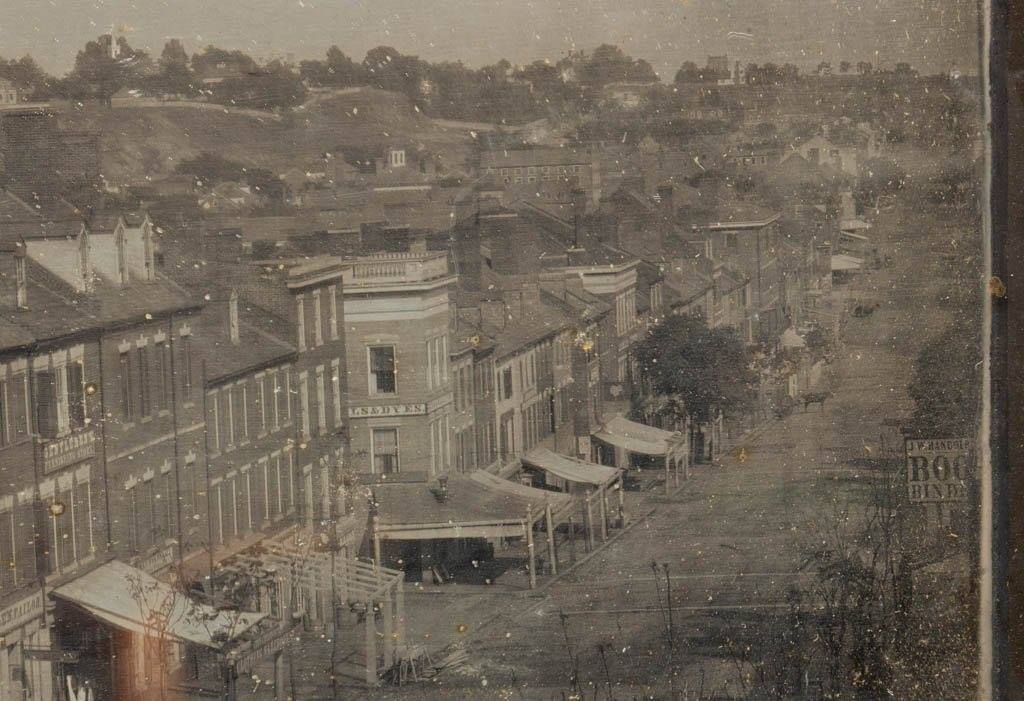
Main Street towards Church Hill (1856)
Stolen shamelessly from Harry Kollatz’s Facebook:
Main Street looking toward Shockoe and Church Hill, 1856. The “daguerrean gallery” of William Abbot Pratt (he of Pratt’s Castle renown) is behind us, to our right — or we’re in his building at 145 Main.
[…]
We are looking directly into Shockoe, and its nest of slave merchants and the infamous Lumpkin’s Jail. The First Market building — it was just a few years old then — is lost in the jumble of buildings and shadows toward the bottom of the hill. But if you travel our eye from the “DYES” sign, to the widow’s walk banister, and past some roof tops, you’ll see the cupola of the Masonic Temple — which still stands. And somewhere up there on Church Hill — perhaps just out of frame (others, whom I hope I will visit this post, know that landscape better than I) is the house of Elizabeth Van Lew. NIne years later when Richmond’s business and financial districts were immolated, Mrs. Van Lew had a box seat on her veranda for this Wagnerian end.


Someone passed along a link to me of this as well. It was from a auction site. Always great to find new pictures!
Look at those awnings!
This is an amazing photo, thank you for sharing!
Too bad you can’t put up an awning on Main street these days without paying a tax on it.
This is looking East at the intersection of N 2nd and E Main. The store on the right is J. W. Randolph Book Binder was at 121 Main and Charles Ellis on the left is 106 Main.
The building with the large awning in the center looks to be the size and shape of 200 E Main, Africanne on Main. Though, I’m sure that building is much newer than 1856.
http://eservices.ci.richmond.va.us/applications/propertysearch/Detail.aspx?pin=W0000047025
Eric, the topography doesn’t look like 2nd and Main. If it was at 2nd and Main, we’d see 2nd Presbyterian pretty clearly. That does look like the Masonic Lodge with Church and Libby Hills in the background.
Sean, you are correct in your location where the apartment building-slash-restaurant Africanne is today. It is also not the same one in the picture as it had an angled corner and side windows that the current building don’t have there nor ever had.
The city gave it a generic build year of 1910 as they do with many properties rather than doing the research.
All of the original buildings on that side of the block are long gone. There are two buildings in the 100 and 200 blocks (odd side) which may be originals but not seen in the vintage photo due to the angle taken.
It (200 E Main) is currently up for sale if anyone is interested?
http://www.loopnet.com/Listing/18506242/200-East-Main-Street-Richmond-VA/
Folks, I think it’s actually much closer to Shockoe Bottom than the 200 block of E. Main. Just look at the cupola of the masonic temple. That doesn’t seem like it would be 15+ blocks away from the vantage point in that picture. Instead, I think this shot is taken from a much closer location – perhaps somewhere between 12th and Main and 14th and Main. The topography/slope of Main in that area today seems similar to the slope of Main in the picture.
#11- David is right. If that shot was taken from 200 E. Main you would also see the Capital building in the left center. Probably taken from about 12th, especially if you figure that the Masonic Lodge is on 18th. Just count the blocks on the left.
I ran across something odd last night when a business address from 1854 said it was 120 Main but also said at the corner of 13th and Main?
Did they renumber after that where today the 200 block is at 2nd?
Eric
Judging by what I see, I would say that the nearest intersection is most likely 14th and Main.
Everyone should have figured out, through this string, that the pre-fire addresses have little correlation with our modern numbering system. Our current numbering system was clearly in place by the mid-1870s (Frederick W. Beers’ Illustrated Atlas of Richmond, 1876). The 1860 business directory listed J.W. Randolph at 121 Main Street. If the cross street is, in fact 14th, then Randolph’s address, according to the Beers map, would be 1329 East Main.
The St. Charles Hotel (four stories high) is visible about three quarters towards the right, at the bottom of the hill. It was the only full, four-story building in that general vicinity, while most others were three and a half, at best. That building was on the northeast corner of 15th and Main.
…And, looking at Beers, there were a couple of alley access points off Main in the long block between “old 14th Street” and 15th. Among them was Locust Alley. Continuing north across Franklin, Locust became Mayo Street… which is modern day 14th Street. If you look closely, you can just make out a few breaks between buildings between the Dyes building and the horse (near the St. Charles).