RECENT COMMENTS
Eric S. Huffstutler on What is up with the Church Hill Post Office?
lanny on then it happens to you...
JessOfRVA on then it happens to you...
Becky Metzler on Updated! Guess what's happening on Mosby/Venable?
Mary on then it happens to you...
Sid on then it happens to you...
Becky Metzler on Church Hill Startup Tackles Insurance for Freelancers
vacant lots in Union Hill
07/10/2008 3:00 PM by John M
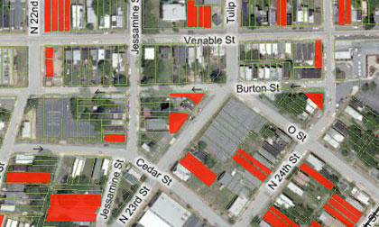
As part of the on-the-ground work towards a possible Old&Historic designation for Union Hill, volunteers have scoped the area and identified the vacant lots in the area. Check out the map and drop’em a line if you have any corrections/additions.
UPDATED 7/14: The map has been updated to reflect community input.


My thanks to the volunteers for all the work that went into this.
A couple folks have already sent me corrections and we really appreciate it.
Two vacant lots were noted at the corner of 23rd and Jessamine, and we corrected an error on the 2410 M (houses on them there lots!)
Thanks for helping us update the map so it can be as accurate as possible. -Elaine.
I know I probably don’t count and people have carved up the city in other “districts” and stuff… but I believe Union Hill jumps 25th St.
Cadeho, good question. Here’s the answer:
In 2000-01,the area was exhaustively surveyed and inventoried for the National Park Service. In 2002 Union Hill was placed on the National Register of Historic Places, making it a Federal and State Historic District and providing Restoration Tax Credits for homeowners.
The eastern boundary of 25th Street was determined by historical maps of the area and the growth of the original antebellum “village” of Union Hill.
In the earl/mid 1800’s, Venable Street was our lifeline, the “main drag” and our only link to the city of Richmond because it happened to be stage coach road to Williamsburg.
When the village of Union Hill was in it’s infancy, a deep ravine and seasonal creek ran along what is now Jefferson Avenue creating our southern boundary. That ravine isolated us from the rest of Church Hill. The bluffs above Shockoe Valley form our western boundary.
For more insight, check our the 1864 Richmond Map (map_richmond_1864.gif) that is here on the CHPN site.
I know it seems kinda odd that we would have to draw a line somewhere, especially when we 21st century folk cross back and forth over 25th street and feel like we’re still in the same neighborhood (in modern times I believe we all think of ourselves as living in ‘greater church hill’.)
But for practical purposes, like National, State and Local historic districts, the lines have to be drawn somewhere. That’s where the historians come in and do the digging back in time. After all that’s what makes it an “historic”: going back to the original boundaries, before roads were graded and modern roadways built.
Hope that helps explain things.
Thanks Union Hill, I am aware of the hstory of Union Hill but I was saying that in my book (figuratively speaking) and map I’ve drawn, Union Hill goes to 27th. After all even that map above is including O St and Carrington as boundaries. Now for the true settlement, east of 25th is right, but I think as a neighborhood, it’s grown and some of the architecture can help define too.
The question I have now though is that I’ve alaways wondered about Venable ST. I did read it was a road into the country but where it went was not stated. How did it go to Williamsburg? Did it link up with that knin that’s been erased from 31st St when it was Newbridge Road and followed that to Williamsburg Road?
Ah, Venable Street…that’s a good question. I honestly don’t know how it ran further east. We’ll have to research that and see what we find. You very well may be correct on that.
BTW, this is an open invitation for all us jr-historians, and even the pros to figure out the route.
Wow… I am glad you were able to read that question because the word “kink” somehow came out “knin.” I love old maps. This would be interesting to find. How did you find out it was a stage coach road to Williamsburg? It seems we had a couple of those in Williamsburg Road and New Market Road.
cadeho-the vcu urban studies grad students who focused on union hill last semester dug up that gem. remind me to go back to their final report and i’ll find the source…but ask me in a year or so, once we’ve got our city old and historic district designation in place. (that’s about the time we’ll be coming up for air…to do fun stuff like this.)
Haha ok.