RECENT COMMENTS
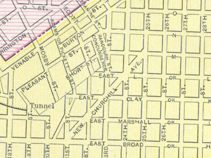
An older map of Richmond and Manchester
Another map with some older versions of the street names around here (here and here, previously), this is the first that I’ve seen that identifies Jefferson Avenue as “New Churchill Avenue”. Neat also is the inclusion of the ends of the Chesapeake & Ohio train tunnel under Church Hill, all of the named streets in Union Hill, and Nine Mile Road labelled as “New Bride Road” (which has to be a mistake on “New Bridge”, right?).
The cover for the map identifies the map solely as “1897”, though the map actually shows the pre-1892 boundaries of the Richmond (just before the annexation of the area from Grove Avenue to Broad Street west of Lombardy Street to Boulevard). The cover attributes the map to George Craw.
The map also includes the Central Lunatic Asylum, which moved to Petersburg in 1882.
TAGGED: map


Love the map, John! Is a “horse railroad” a horse-pulled streetcar, do you think?
It’s the right time period for that. I’ll have to dig up my copy of Rails in Richmond and see if that has a map or description of the old horsey routes.
Let’s bring back the old street names! I like them.
Why does that map look familiar… besides me probably having it. Where did you get that? You should see this 1890 map I have.
I picked it up at the antique thing at the Showplace this past weekend. It is a page from a book of unknown origin, with a similar map of Pittsburgh on the back.
There are two of these maps on Ebay right now for anyone interested.
I have always wonder why…
Addresses starting with the 300 block are N (North ) while addresses falling below that between 1-299 are S (South) even though we are North of the James and the addressing system should be sequential from 1-through whatever?
And the numbered street names duplicate in part on the Southside but are listed as W (West) addresses?
What is up with this?
An afterthought is that the N versus S address are North of Broad and South of Broad but if so, why did they not restart the numbers and have in example a 100 S. 25th and a 100 N 25th like the norm?
But that still does not explain the West addresses on what is called the Southside?
Main Street is the dividing line between North and South street numbers. When south of the river number streets were created they were in Manchester which was a separate city until being annexed into Richmond in 1910. Fouchee St. is the dividing line between east and west designations in downtown.
Thank you Mr. Hartsock. But I am still a bit confused. Not all of the streets go all the way through and most end at Cary right? If Marshall to Clay is the 400 block, Broad to Marshall the 300, Broad to Grace the 200, Grace to Franklin the 100, and Franklin to Main the 10 then anything on the other side of Main is “South” which is basically only one block? Why didn’t they just renumber years ago in the 1840’s or whenever, to have that block inclusive with the North numbers? Isn’t that a bit odd to have it separate when the streets were already established long before then?
I’m guessing at this point, but when the streets were first laid out in 1733 the only one that ran all the way through town from east to west was Main Street. The topography of Shockoe Valley made the other streets difficult to continue through town. If you go farther west you see that the number streets go below Cary and by the time you get past Belvedere they go much further south, though they have names at that point, i.e. Laurel, Cherry, Harrison, etc.