RECENT COMMENTS
Eric S. Huffstutler on What is up with the Church Hill Post Office?
Eric S. Huffstutler on What is up with the Church Hill Post Office?
Yvette Cannon on What is up with the Church Hill Post Office?
crd on Power Outage on the Hill
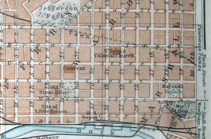
Route of the Church Hill train tunnel
03/09/2009 5:50 AM by John M
In addition to having a line for the route of the Church Hill train tunnel, this map also shows both Libby Hill and an adjacent Marshall square making up what we know of as today’s hillside park. Union Hill still had Pleasant, Pickett, and Scott Streets.
The undated map shows Main Street Station (built in 1901), but can’t be much more recent than that.
Much thanks to Bill Hartsock for sharing.


The map also indicates “Byrd St. Station” at the corner of 7th and Canal. Does anyone have any information about this building? I had never heard there was a train station located there.
I’ve always wondered exactly what that route was. Thanks for another great scoop!
Stuart: According to “Richmond, the Story of a City” by Virginius Dabney, the R.F.&P (Richmond, Fredericksburg, and Potomac)operated Byrd Street Station, located at Byrd and Eighth Streets. The station was eventually replaced by Broad Street Station. It was said to have “rudimentary facilities”, so it must have been pretty basic.
I have this one too — tried to find the record of the eBay auction I bought it on many, many years ago but can’t seem to find that. I’ll keep looking, but I believe the date on this to be 1909.
@Stuart: I have an undated map (looks to be removed from an atlas) showing that 7th and Canal as “Pass. Depot”:
http://www.flickr.com/photos/bussefoto/3341203901/in/photostream/
And a 1931 “Map of Richmond, Virginia and Suburbs” by Verner C. Aurell showing that as “A. C. L. Freight Yards”:
http://www.flickr.com/photos/bussefoto/3341200697/in/photostream/
(of note: solid red lines are Street Railway Lines, adject to the west and south edges of that parcel). Sorry for the blurry iPhone pics, I took them in haste to post the comment. I am working to get my collection framed, and will try to scan my maps beforehand.
http://ead.lib.virginia.edu/vivaead/published/lva/vi00025.bioghist
“During the Civil War, the R.F.& P. R.R. operated largely in the service of the Confederate Army. The damage inflicted to equipment, tracks, bridges and buildings was considerable.
In the mid 1880’s the company prospered again. In 1887 the Richmond Byrd St. Station was opened to accommodate the increased traffic volume of the R.F.& P.R.R. Co. and the Richmond and Petersburg R.R. Co. (R.& P. R.R. Co.). In 1888 a timely freight service for fresh fruit and vegetables was inaugurated, a business that should grow fast and steadily well into the 20th century. The same year authorization for a branch line was granted to these two railroad companies, so the growing volume of freight could be directed away from the city.”
http://www.greenspun.com/bboard/q-and-a-fetch-msg.tcl?msg_id=004Zxt
“But prior to Broad St. Station (1919), the ACL used Byrd St Station, several blocks south of Broad St. , nearer to the James River. (R,F,&P also once used this ‘union’ station.) This building was opened in 1887. The station, located at 7th & Canal St, had been used by ACL predecessor Richmond & Petersburg RR. Apparently,ACL freight service remained at Byrd after passenger service moved to Broad St Station in 1919. Althought altered, portions of Byrd St Station remained until the early 1970s, until finally demolished for a freeway.”
Notice the smaller train tunnel to the west of the Byrd Street station that ran under Gamble’s hill. This is always one of Richmond’s lesser-known little facts.
I believe that part of the masonry listing when this smaller tunnel was built is sitting behind Tredegar beside the expressway fence as you drive east down that steep hill.
Wow! Fascinating history, thanks for all the info.
busse- it would be great to see a complete map of the streetcar lines! i think about them every time i pass the exposed rail at Cumberland and Laurel streets.
@Stuart (and anyone else) – email me chrisbusse (at) gmail (dot) come and I’ll make sure you get notified as I get them scanned.
Great stuff everyone. Love it.
The tunnel’s pic is in Mary Wingfield Scott’s Old Richmond Neighborhoods book. http://s28.photobucket.com/albums/c236/RVaPics3/?action=view¤t=ByrdTunnel.jpg
And I know I have another older pic of Byrd St Station, but this one is from Celebrate Richmond. I don’t have my scanner hooked up so I had to take a pic. http://s28.photobucket.com/albums/c236/RVaPics3/?action=view¤t=100_4884.jpg
there’s a cool map presentation/lecture coming up at the library of virginia:
http://www.lva.virginia.gov/news/comm/2009-03-10.htm