RECENT COMMENTS
Joel Cabot on Power Outage on the Hill
Eric S. Huffstutler on What is up with the Church Hill Post Office?
Eric S. Huffstutler on What is up with the Church Hill Post Office?
Yvette Cannon on What is up with the Church Hill Post Office?
crd on Power Outage on the Hill
The Fairmount Expressway?
08/11/2009 6:56 AM by John M
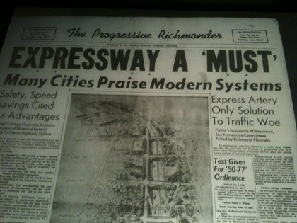
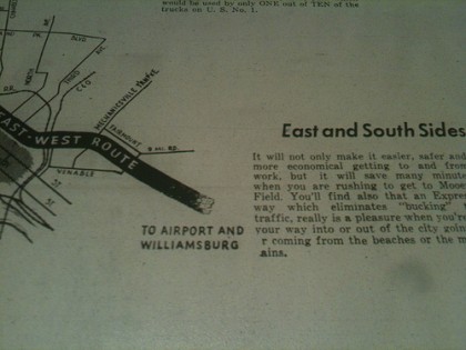
Another stunning recent find was 1950’s The Progressive Richmonder. This single focus (single issue?) paper, published by The Forward Richmond Highway Committee, existed solely to advocate for a downtown expressway. Check out how they proposed to mangle Fairmount and Church Hill North…


What ever happened to “The Progressive Richmonder.” He hasn’t been spotted in Richmond for decades. Did he move out of town, or is he just in hiding? 🙂
There were pregessive Richmonders? Really? Well I’m kind of glad they don’t exist or they’d destroy stuff. Look at that! I guess the current path of 64 was the better choice although it destroyed Sebree’s Addition instead.
Is there a better picture of the map sketch from the front page? I can’t make out how it runs through Church Hill North as mentioned.
This is all they had. The simple map above shows the proposed expressway crossing 25th just north of Venable/Q Street and proceeding parallel to Q Street.
The rendering on the cover page looks like a rendering I saw for converting Route 1 (Belvidere Street) into a limited access highway from the City’s 1st comprehensive plan, one that may have carried I-95 through the City during the early planning stages.
Ryan, it is… I see Franklin, Main, Cary, and Byrd streets.
Was this before I-64 went online? Seems crazy to propose another major highway so close to an interstate already in use…
Looks like this would have followed the route of the Martin Luther King, Jr. bridge, and cut through what’s now MLK Junior High and Mosby Court South, possibly. Has anyone seen photos of these areas pre-1950?
The Stretch Monster: I-64 did not exist in downtown Richmond until 1968. I’d have to ask a contact of mine who runs the Virginia Highways Project (http://www.vahighways.com), but this isn’t that far south of where I-64 is now. If I-64 had been built here, it would have destroyed much of the Fairmount and Church Hill areas much like I-95 divided Jackson Ward.
I can’t really tell but the image on the cover looks like I-95’s current position, but only as a depressed freeway (similar to where I-95 and I-64 currently overlap) and not an elevated one. This wouldn’t have worked at all.