RECENT COMMENTS
Joel Cabot on Power Outage on the Hill
Eric S. Huffstutler on What is up with the Church Hill Post Office?
Eric S. Huffstutler on What is up with the Church Hill Post Office?
Yvette Cannon on What is up with the Church Hill Post Office?
crd on Power Outage on the Hill

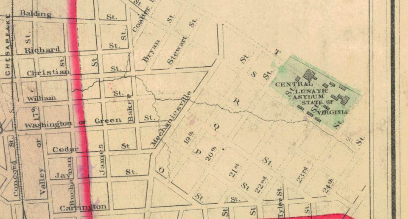
Richmond map 1883
02/18/2010 6:40 AM by John M
O.W. Gray and Son, 1883. Pre-Jefferson Avenue, shows the Central Lunatic Asylum, the route of the train tunnel, and offers up the alternate letter names for Clay, Leigh, and M/N/O Streets.


Wow – great map! Any idea if some of the buildings from the Asylum remain standing? I don’t think I’ve ever heard of it. I wonder if it was a City hospital or part of the State system.
Here is what I’ve been able to find out about the asylum: http://chpn.net/news/2008/07/09/a-short-history-of-the-central-lunatic-asylum_1773/
When we had the beer vault discussion, that article referenced a tunnel through Chimborazo which confused me. The only old tunnel I know of is the one that went thru Jefferson Park and collapsed and I couldn’t understand how it was supposed to continue to the far east end of Chimbo @ 36th (ish?). This map shows the rail tunnel ending and becoming tracks again at 30th and Grace.
I also thought it was interesting to see 29th and Main noted as “Marshall Square”. I know that area today as Libby Hill Park.
Thanks for posting these historic maps. They are a good reference for us here at our office.
I always wondered why the city’s letter grid was so discontinuous, now I know! Phew.
Wonder if this was the mental institute for white people? What became Central State in Petersburg was not far away.
http://ead.lib.virginia.edu/vivaead/published/lva/vi00940.bioghist
Our neighborhood Central Lunatic Asylum shown on the map above is indeed the institution that became Central State.