
RECENT COMMENTS
Eric S. Huffstutler on What is up with the Church Hill Post Office?
Eric S. Huffstutler on What is up with the Church Hill Post Office?
Yvette Cannon on What is up with the Church Hill Post Office?
crd on Power Outage on the Hill

White flight in Richmond (1960-2010)
07/07/2017 9:10 PM by John M
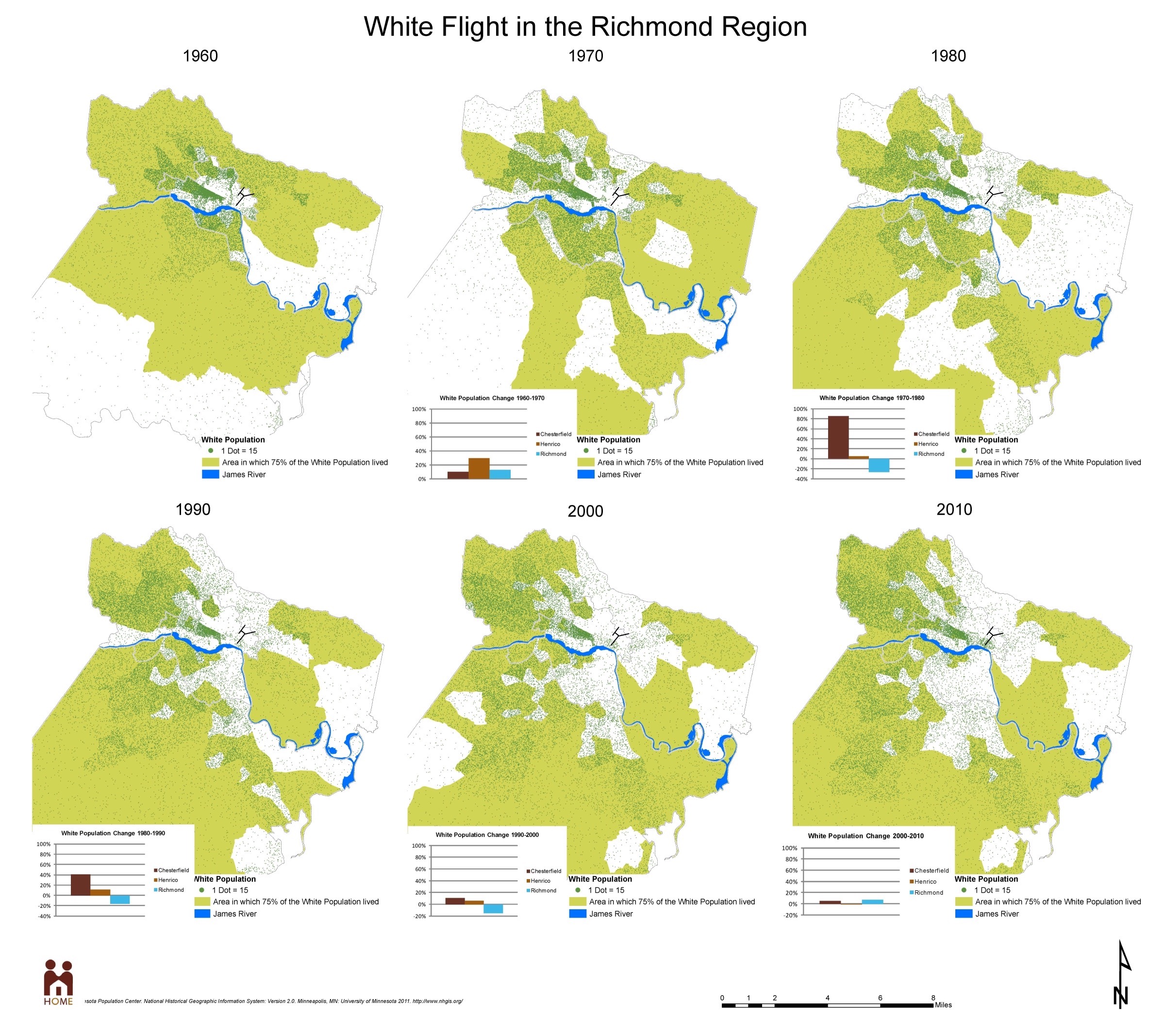
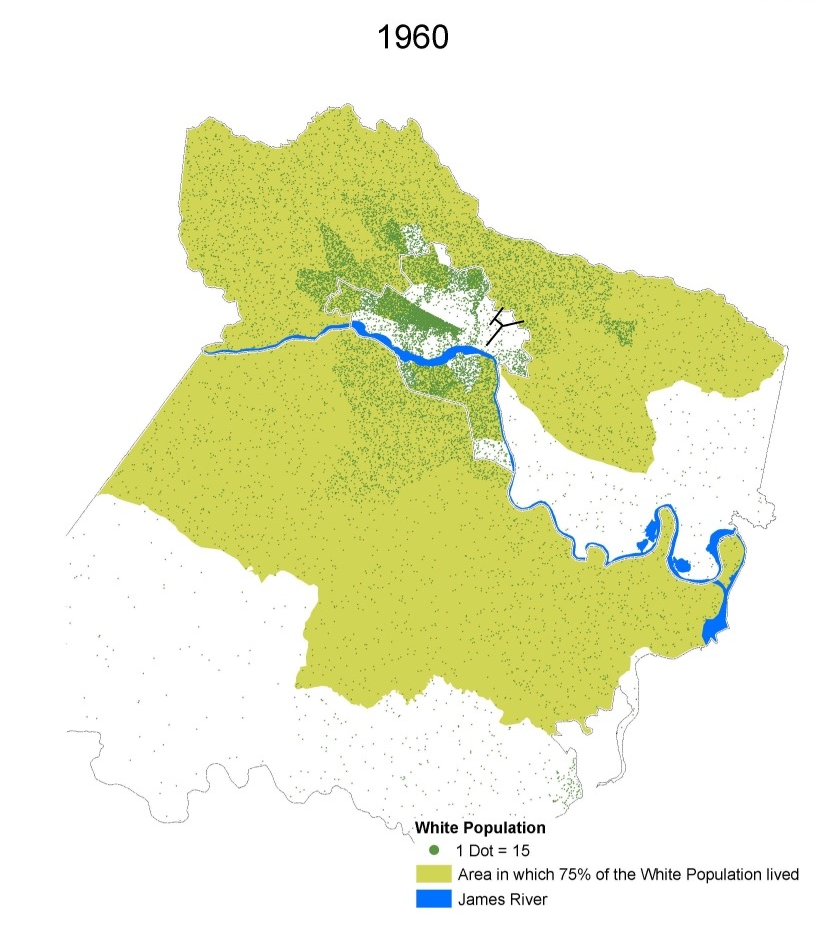
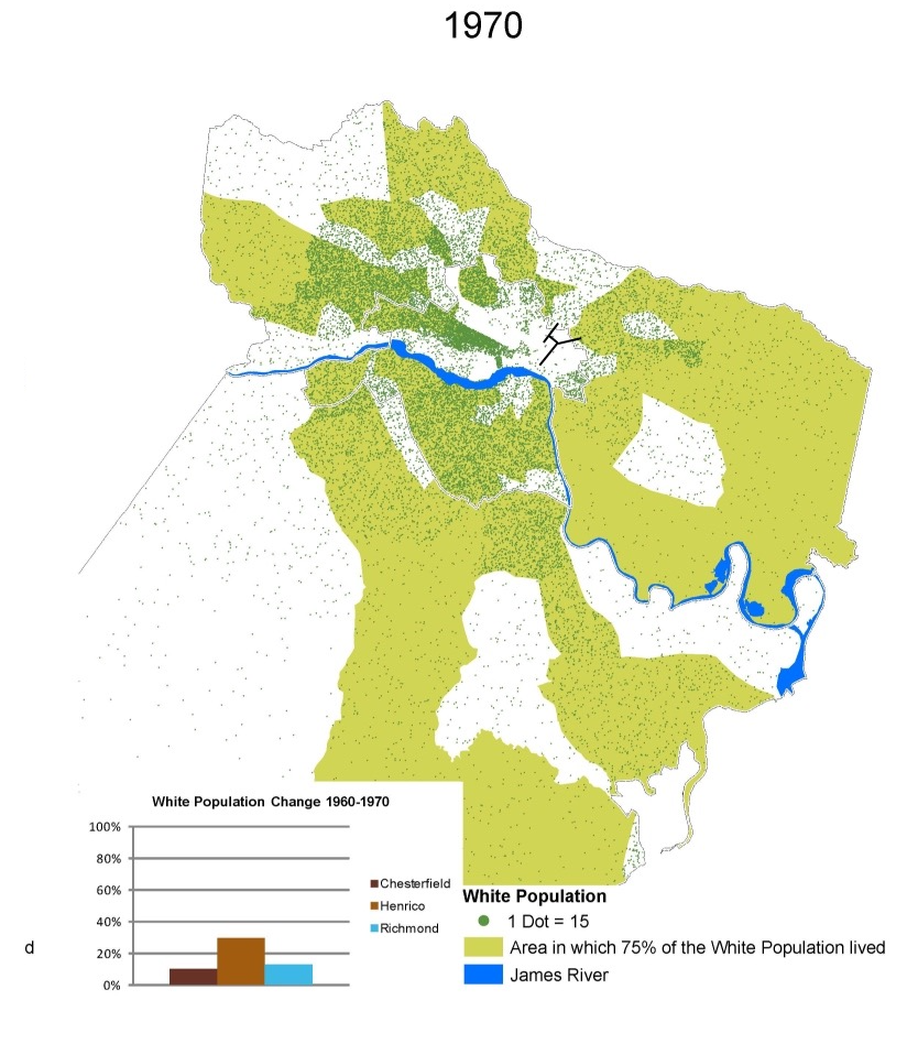
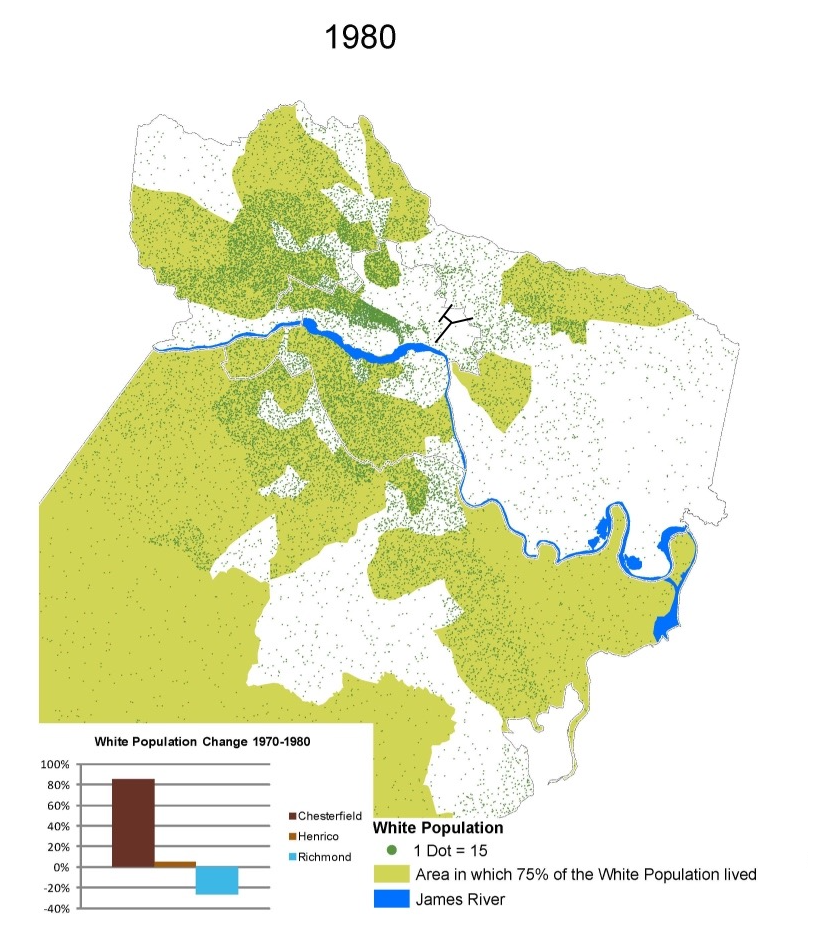
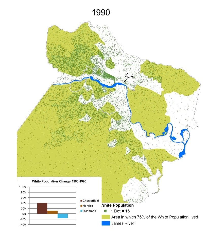
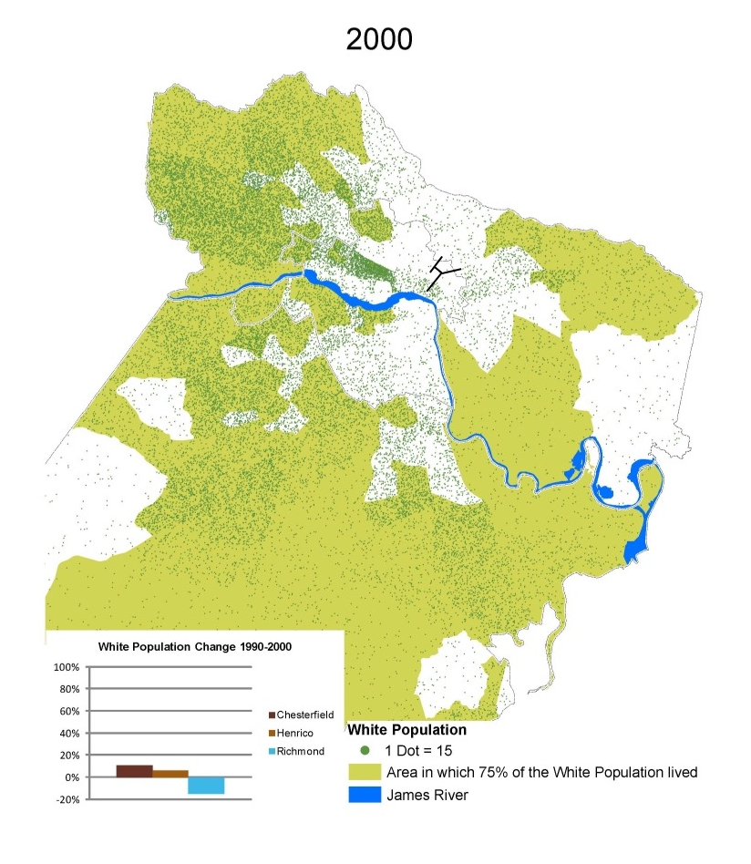
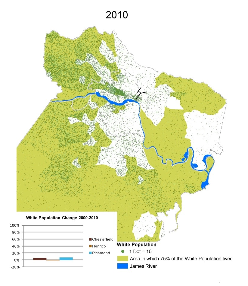
Found this neat map on Brookland Park Post showing white flight from 1960 through 2010, in Richmond, Henrico, and Chesterfield. The light green marks the area encompassing 75% of the white population at the time, and each dot represents 15 white people.
I’ve added the black lines, which mark 25th Street, Nine Mile, Fairmount Avenue, and Mechanicsville Turnpike (to the city limits).
Some observations:
- The city’s white population dropped from sometime in the 1970s to sometime in the 2000s.
- The greater Church Hill area looks to have experienced “peak white flight” some time before 1980.
- Very little of the city is inside the “white 75%” at this point.
- The East End hasn’t even been adjacent to the “white 75%” since the 1990s.
Not sure how the population change graph for 1970 handles the annexation.
— ∮∮∮ —
— ∮∮∮ —
— ∮∮∮ —
— ∮∮∮ —
— ∮∮∮ —
— ∮∮∮ —
— ∮∮∮ —
It would be interesting to see how the maps have changed from 2010-2017.
Why stop at 2010?
Census data is every 10 years.
Yeah, now they want to come back and out price the people who have been here for decades.
The light green "Area in which 75% of the White Population lived" appears to have fairly arbitrarily chosen which 25% to leave out – either that, or it’s purposely drawn to exaggerate the progression of the flight out of the city. For example, on the ‘2000’ map, there are areas of the city left out of the 75% green area that are indicated to be clearly more densely white populated than some of the rural areas that are included in the 75% green area. Is there some other reason not given that I haven’t thought of that explains this?
I’m guessing it’s just mislabeled and should probably read: "Area in which 75% of the Population was White".
They don’t want to come back, their kids do.
A city in decline either accepts new population (and whatever change that brings) or slowly withers and dies.
I’m happy to see all of the people who want to live in our city put pressure on the city itself to be better, and maybe one day, great. Lord knows e need it.
I hope that they also put pressure on themselves to be good and principled and caring and strong.
Richmond nor any city in Virginia will be a great city one day unless the politicians cut all the regulatory bull crap and bring big sports here. Until Virginia will just be one big interstate to get you to D.C./Bmore or Charlotte and ATL. Yawns
Wrong, wrong, wrong J – again, why don’t you figure out what Richmond has to offer? Awesome art scene (music, visual, dance – everything!), great museums, tons of neat history things, great street parties, super-engaged citizenry. And if you MUST have sports, what about following all the college teams in Virginia? That’s what my sporty Richmond friends do. So confused by you – you are very limited in your interests. Richmond attracts lots of interesting people which makes this a very interesting city. Pro sports teams can suck all the civic energy out of a community, I’m actually glad we don’t have any here. I’m sorry the only thing that interests you is pro sports. Seriously, get out and check out the great city you live in (or maybe you should leave).
The first big change era was omitted above. 1950-1960 where it went from 75% white to 96% black within those 10-years.
This was due mostly to desegregation of schools in 1954 (Brown v. Board of Education). By 1955, “Time” magazine did a report card of Southern states on how they were handling integration and Virginia got a D+, falling barely ahead of the notorious prejudice deep South states of Alabama, Georgia, Louisiana, Mississippi, South Carolina.
A policy of “massive resistance” (“Southern Manifesto”) was declared by Virginia Senator Harry F. Byrd in 1956 and led to the closing of nine schools in four counties in Virginia between 1958 and 1959. They were in Warren County, Prince Edward County, Charlottesville, and Norfolk.
You may want to also check out this 2014 post here on CHPN entitled: “Richmond is the 39th most racially segregated city in America”
https://chpn.net/2014/08/16/richmond-is-the-39th-most-segregated-city-in-america/
It’s mind-blowing to consider how deep racism is that literally thousands upon thousands of whites threw out (sold at a huge loss or just abandoned) the most expensive investment they would have in their entire lifetimes (thier houses) just so their kids would not have to sit next to black kids!
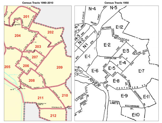
Here’s census tract level data for the East End from 1950 though 2010, except for 1980.
Note that the tracts themselves are not directly comparable across the decades. The maps for 1950 and 1990-2010 are below, I couldn’t find 1960 or 1970.
Two HUGE takeaways:
1) The East End was essentially racially balanced in 1950, with 2 super white tracts in Fulton. By 1960, a giant shift had occured.
2) The general population of the area dropped for more than 40 years – from ~1960 to 2015 (see here)
Click to view larger
EAST END CENSUS TRACT POPULATION 1950-1970 and 1990-2010
EAST END CENSUS TRACT MAPS
@12 Max, People of that time and up into the 1970s, had a strong constitution about segregation.
Take for example the 1968 Presidential candidate and former governor of Alabama, George Corley Wallace Jr (1919-1998). He was a well known segregationist and did not run to win but to divide parties and gain house seats. Those same “deep South” states I mentioned who got an ‘F’ on their report card by “Time” magazine in 1955, were the same states he won the electoral votes in. At his 1963 Gubernatorial inaugural address, he said these now infamous words: “segregation now, segregation tomorrow, segregation forever”. Wallace as Alabama Governor, served two nonconsecutive terms and two consecutive terms as a Democrat: 1963–1967, 1971–1979 and 1983–1987. Wallace has the third longest gubernatorial tenure in post-Constitutional U.S. history, at 16 years and four days. People in Alabama must have loved his rhetoric.
It appears that even in the 1980s, racial tensions in the deep south still ran high. I know this personally because, I once lived in a small town just outside of Mobile, Alabama in 1978-1979, called Chickasaw. It is 4.2 square miles, can walk border to border along the main drag in 10 minutes, had 13 churches, zero entertainment, and was 100% white (and intended to stay that way). In other words, KKK territory. As a gay person, I was allowed to live there safely because I was compiling a history of the town until two factors changed that forever. First, Hurricane Frederic came through in September 1979 and nearly wiped out parts of Mobile and surrounding areas. Second, I uncovered some skeletons that they wanted to remain in the closet. That the town, which had a small shipyard with supporting community, once built WWII era Liberty ships and was still importing slave labor from the islands to build them.
People do get passionate over many social issues… just like the McCarthy era and people who were paranoid about a Communist takeover of America. Or Civil Defense and the threat of Nuclear Bombardment by the Soviets.
We still see racial division today and self administered segregation.
John M. just brought back up a 1902 article about the up and coming community of Fairmount. Thanks as it was going to be used as part of my background history for a personal house research project in Fairmount that I am working on 😉 But this bit in the article I found interesting and is somewhat related to this post…
“At the present time there are in Fairmount about 175 houses, mostly plain and of frame, but substantial and neat. The population is made up of about 700 white persons. By a stipulation made when the Fairmount Land Company was in control, no property can be sold to negroes, certainly not before 1917. There is, however, one negro family in Fairmount, which was there before the land company came into possession, and which now won’t get out.”
I thought this article is also interesting, and includes this quote – “Some neighborhoods, such as around Church Hill, changed from 75 percent white to 95 percent black between 1950 and 1960.”
http://statchatva.org/2015/04/07/richmonds-quiet-transformation/
Written by the same people who did the racial dot map – http://demographics.virginia.edu/DotMap/
@16 Stephen Weir, I was a percentile off but is basically identical to what I said in my post @11 above. 🙂
Great link Stephen! That article has a lot of interesting facts about what is currently going on, too.
Richmond was famous for "Red-lining" policies that suppressed those left behind with minimal tax dollars spent on infrastructure, education, services, etc.
More on red lining:
Residential Security Map of Richmond from the 1930s
https://chpn.net/2009/08/27/residential-security-map-of-richmond-from-the-1930s/
Mapping Inequality shows relation between racism and the built environment
https://chpn.net/2016/10/31/mapping-inequality-shows-relation-between-racism-and-the-built-environment/